Home / LiDAR Services
Modern industries rely on spatial intelligence to drive automation, safety, and operational efficiency. Tecnoglance Consulting’s LiDAR data services help convert raw 3D sensor inputs into meaningful spatial understanding—supporting autonomous navigation, infrastructure development, and environmental mapping.
Using advanced techniques in 3D data processing, we help classify, segment, and track objects across sequential LiDAR frames. Our team supports both domestic and international clients who rely on high-quality spatial datasets to power ADAS (Advanced Driver Assistance Systems), urban mapping, and environmental modeling.
Whether onsite or remote, our experts deliver consistent results using industry-standard tools and workflows. We’ve built a reputation for precision, scalability, and timely delivery across a wide range of LiDAR applications.
LiDAR Data Services are crucial for enabling autonomous systems, smart infrastructure, and geospatial projects. By converting raw point cloud data into structured insights, Tecnoglance Consulting helps organizations achieve accuracy, safety, and efficiency. Obtain reliable outcomes seamlessly within the required timeframe.
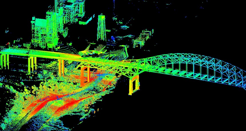
Our LiDAR data processing services empower organizations to transform raw point cloud data into actionable intelligence. With our expertise, you can manage spatial information efficiently—supporting autonomous navigation, infrastructure mapping, and environmental modeling. We deliver precise object detection, tracking, and classification across sequential frames, ensuring accuracy and reliability for your projects.
Contour generation services help you extract terrain boundaries, elevation profiles, and surface gradients from LiDAR datasets. We provide detailed contour maps that support applications in civil engineering, urban planning, and environmental studies. With our solutions, you gain full control over spatial interpretation and topographic analysis, enabling smarter decision-making and project execution.
We convert LiDAR point cloud data into precise terrain and surface models. Our DTM and DSM outputs support civil engineering, urban planning, and environmental projects—delivering reliable elevation and surface insights for smarter decisions.
Our advanced classification services organize LiDAR point cloud data into meaningful categories such as ground, buildings, vegetation, and infrastructure. This enables accurate mapping, better environmental analysis, and smarter planning for industries like transportation, urban development, and resource management.
Our powerline classification services use LiDAR data to identify and map transmission lines, poles, and surrounding vegetation. This ensures accurate monitoring of utility corridors, supports maintenance planning, and helps prevent risks such as line encroachment or vegetation overgrowth.
Our hydro project services use LiDAR data to map rivers, reservoirs, and catchment areas with precision. These insights support dam construction, flood risk assessment, and water resource management—helping you plan and execute projects with accuracy and efficiency.